Categories
Allgemein

Conclusion

Throughout this module, I have gotten so incredibly much knowledge of remote sensing. It was great to have a combination of a lecture and a computer class. In the entire semester, this was definitely my favourite class because I learned the most.

As I have mentioned in my blogposts, remote sensing can be useful in so many different fields of geography. I definitely did not expect that and I am glad I got a lot of practical knowledge as well. At my home university classes such as remote sensing are not offered, so I am sure I do stand out with ENVI skills and remote sensing knowledge. Thanks to the learning blog and reading into remote sensing-related topics, I really got into it and already figured out, which remote sensing related aspects I really enjoy.

Remote sensing has definitely given me a lot and I did not only gain knowledge, but most importantly skills. I am not entirely sure, what I want to focus on in my dissertation or postgraduate yet, but I am convinced that I will make use of remote sensing in my dissertation. I hope you enjoyed reading my blog and hopefully also learned important things and interesting remote sensing-related aspects.

Categories
Allgemein

Remote Sensing and Natural Disasters

In one of our first sessions, we had to pick a satellite photo and present it in class. I picked an area damaged by flooding of a tsunami, which woke my interest in the natural hazards in the field of remote sensing. Since there are so many natural disasters, it was difficult to pick one. Luckily, I found a table that gives a great overview of the hazards and what remote sensing has to offer.

Table 1: Ways remote sensing can help disaster management (Lewis, 2009)

DisasterMitigationPreparednessResponseRecovery
CycloneRisk modelling; vulnerability analysis  Early warning; long-range climate modelling.  Identifying escape routes; crisis mapping; impact assessment; cyclone monitoring; storm surge predictions.  Damage assessment; spatial planning.  
EarthquakeBuilding stock assessment; hazard mapping  Measuring strain accumulation.Planning routes for search and rescue; damage assessment; evacuation planning; deformation mapping.  Damage assessment; identifying sites for rehabilitation  
FireMapping fire-prone areas; monitoring fuel load; risk modelling.  Fire detection; predicting spread/direction of fire; early warning.  Coordinating fire-fighting effortsDamage assessment
FloodMapping flood-prone areas; delineating flood-plains; land-use mapping.  Flood detection; early warning; rainfall mapping.  Flood mapping; evacuation planning; damage assessment.  Damage assessment; spatial planning.  
landslideRisk modelling; hazard mapping; digital elevation models.  Monitoring rainfall and slope stability.Mapping affected areas;Damage assessment; spatial planning; suggesting management practices.  
VolcanoRisk modelling; hazard mapping; digital elevation models.  Emissions monitoring; thermal alerts.  Mapping lava flows; evacuation planning.  Damage assessment; spatial planning.  
DroughtRisk modelling; vulnerability analysis; land and water management planning.  Weather forecasting; vegetation monitoring; crop water requirement mapping; early warning.  Monitoring vegetation; damage assessment.  Informing drought mitigation.

The table is split into four different parts of a so-called disaster cycle. Mitigation shows the long-term efforts of preventing hazards, preparedness presents the planning, response shows the immediate plans afterwards and recovery is the final step of restoring the destroyed area.

Some satellites even carry tools, which can be very useful for disaster management. Some thermal sensors are able to detect fire, infrared sensors can detect flooding and microwave sensors on the other hand are able to measure the changes of earth before and during volcanic eruptions and earthquakes. It is possible to see how incredibly much remote sensing has to offer regarding this topic. Without Remote Sensing, many people would suffer more intense from the hazards (Lewis, 2009).

Source:

Lewis, S. (2009) Remote Sensing for natural disasters: Facts and Figures. SciDevNet (available at https://www.scidev.net/global/earth-science/feature/remote-sensing-for-natural-disasters-facts-and-figures.html?__cf_chl_jschl_tk__=fec36c0d388a01a965f3adb4a21e3b91e5a2c2f5-1579137782-0-ASjDnL0EQlGsITqOymfqhxZFUAYzH_XYgqL3Rn7pznUfWWDQii7In48LWZravrH8zBeiJKKDnX216oH8odok293TwkibgGjqaajfTgCNei1oRke_Hehsv72mM1JA847Rc2EpDQjy7r1SRiXiG62FUASZW2paqWDgwDi_djH04Y13lkU-8yhagrG4RCPclQblYbp2ns5N1rXmq5YRczSkK9zb3YU5vTCrSkJViqVaZui13-jyWHVsfBwBLUii43qx5DHwZbM1njiDiy3zPbEb-OjP1E4dj5GDBuvGP03Jhz1BcyYV74hvqC0ozFh5gEWlVlGxppjkZdJuRkdNVZHq4vHTcZxqzqPIE7J1cIP8TdRwTFtv0Q9vxfRyeLw_SoeqiA)

Categories
Allgemein

Remote Sensing and Human Geography

So far, we have mostly talked about Remote Sensing in combination with physical Geography. Especially in the practicals, we mostly looked at landscape types and other aspects, that were part of the physical Geography spectrum. I told my Erasmus Geography friends, who only do Human Geography about remote sensing and they were said that they have heard of it, so I was wondering how much remote sensing can actually be used in Human Geography. I was browsing through the internet, looking for some interesting articles, I stumbled upon a very interesting way of using remote sensing in Greece. During Greece’s hard times close to bankruptcy, the tax authorities used remote sensing to catch tax evaders. Thanks to the satellites, they found out that in Athens there were over 16,000 private swimming pools, out of which only 324 were reported. The government figured out the amount of tax evaders and rich people pretending they have less wealth and income than they do (Doctorow, 2010).

Talking about problems in cities, Remote Sensing can also prove quite useful for urban issues. Transport problems has been proven as one of the biggest problems, especially in times of big population growth. Remote Sensing is able to efficiently manage the transportation problems as well as urban growth and further developments, such as pollution, water and waste management. Another popular topic is the urban heat and climate change. Remote Sensing enables people to visualize things better and get them under control more easily (Mdpi.com).

One final, interesting thing I found was created by the United Nations High Commissioner of Refugees (UNHCR), who wanted to offer refugee services in Tongo. They were using satellite images to look at the refugee camps and find displaced refugees (Tremeau 2018). To achieve that, they mapped the influx of refugees, infrastructure as well as waterways, which enabled them to offer better help in the places where it was most necessary (Remote Sensing applications, 2014).

Sources:

Doctorow, C.  (2010) Satellite photos catch Greek tax-evaders, (available at https://boingboing.net/2010/05/04/satellite-photos-cat.html)

100 Earth Shattering Remote Sensing Applications & Uses (2014) (available at: https://gisgeography.com/100-earth-remote-sensing-applications-uses/)

https://www.mdpi.com/journal/remotesensing/sections/urban_remote_sensing (accessed at 06.11.2019)

Tremeau, V. (2018) Global Trends – Forced Displacement in 2018 (available at https://www.unhcr.org/5d08d7ee7.pdf)

Categories
Allgemein

Monitoring Glacial retreat

A few months ago, I have attended a Geographical congress in Austria, where I took part in an interesting workshop. It dealt with using remote sensing and GIS to monitor glacial retreat. Back then, I never worked in those fields before, but I remembered our workshop`s topic in my remote sensing class.

Around 11% of the earth`s surface is covered by glaciers. The shrinking and melting of glaciers is a result of climate change, which is becoming a more important topic on daily basis. Since the amount and size of the ice is difficult to measure, remote sensing offers a great opportunity for getting precise information on it. Due to the high albedo and reflectance of glacier ice (50 – 80%) easy data identification. The changes can be identified through the satellites. When the ice melts, the water runs off in patterns and remote sensing can be of big help for figuring out the flow of the water. The mapping of this is very important for humans living around in the area as well as for possible avalanches (Aher, 2012).

Glacial retreat in Patagonia (antarcticglaciers.org)

 ASTER and Landsat images have proven as very useful for this, since they provide a regional view of the ice masses as well as a very fine resolution. Due to their long time series of photos, their images can be used for looking at changes throughout the years. Studies have shown the retreat of exact glaciers, for instance the Northern Patagonia Icefield, as visible in the image. Mapping the glaciers of the Northern Patagonian Icefield. Only in a short period of time, a lot of ice has melted off the glacier (Antarcticglaciers).

Yet, not only the retreat of glaciers can be analysed, but also the thinning of certain ice shelves. In the following image it is possible to see the change of thickness of Antarctica`s ice shelves.

(Pritchard et al., 2012)

It is possible to say, that remote sensing is the most useful tool for glaciologist or general glacial studies. Those pictures can also be of big help to raise awareness of the climate change and the current ice melting situation (Antarcticglaciers.org).

Sources:

Aher, S., Dalvf, S., (2012) Remote Sensing Technique for Monitoring the Glacier Retreating Process and Climatic Changes Study. Indian Streams Research Journal 2, 8.

(http://www.antarcticglaciers.org/glaciers-and-climate/glacier-recession/observing-glacier-change-space/) (accessed 16.10.2019)

Pritchard et al. (2012) Nature.

Categories
Allgemein

Remote Sensing and Plant health management

In today’s class we were talking about vegetation and how vegetation reflects and that it is possible to determine the plant’s health. This was very interesting for me, because I am also taking a plant ecology course this semester. In this plant ecology module I have to write a research proposal and I have begun writing about plant health management using remote sensing.

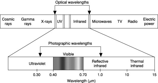
There are three different factors that can show the plants health. The visible green light is reflected the most because the chlorophyll absorbs the blue and red, so their reflectance is low. It is important to note that chlorophyll does not reflect green, since it only absorbs the other colours. The near-infrared can indicate a healthy plant, if its reflectance is high. This depends on the cell structure of the plant. The short-wave-infrared controls the water absorption, which means that it is another indice of the plant’s health (Campbell, 2011).

Therefore, remote sensing can be used widely in the field of plant ecology. Due to the growing awareness of how useful it can be regarding this area, the EU has even launched a programme called Copernicus, which offers access to over 12 Terabytes of images each day. Furthermore, other programmes make a lot of aerial photos available, which are easily accessible. This does not only include satellites, but also drones and small satellites. In addition to that, the enhancement of the technology also increases the speed of photo processing. Especially within plant health management, the usage of remote sensing can be of big importance. Due to certain algorithms, it is now possible to detect insect pests and certain diseases in images. It is possible to see that plant ecology topics, especially plant health management, profit from the advanced technology of remote sensing. It will make research in fields as well laboratories easier (Beck, 2019).

I have done some research and stumbled upon the tool of hyperspectral remote sensing, which has proven very useful in recent studies. The spectral reflectance signatures will be analysed, which can show the relationship between chemical attributes and electromagnetic radiation of each plant. Although it might appear as if remote sensing based on satellites seems to be simpler and less time-consuming, it can carry a lot of negative aspects. The researcher must figure out which spatial detail is required for each sampling. Especially the focus on individual plants would cause issues, since satellite images of this high spatial resolution are not freely available. Therefore, the suggested hyperspectral method would be more cost-efficient. In addition to that, satellite based remote sensing can cause further errors. In recent studies, healthy and unhealthy plants have been mislabelled or entirely disappeared from the image. This could cause the spreading of plant pests. Although the chosen method might be time consuming, it causes less expenses and no errors caused by technology (Beck, 2019).

Sources:

Beck, P., Martínez Sanchez, L., Di Leo, M., Chemin, Y., Caudullo, G., De la Fuente,B. and Zarco-Tejada, P.(2019). Remote Sensing in support of Plant Health Measures –Findings from the Canopy Health Monitoring (CanHeMon) project. Publications Office of the European Union

Campbell, J. B. and Wynne, R.H. (2011). Introduction to remote sensing. Fifth edition. London, New York: The Guilford Press.

Categories
Allgemein

Scattering as a reason for aurora borealis

In my first year of studying at my home university, I was taking a physical geography module, in which I had to do a very big presentation on Icelandic volcanoes. As an introduction, I was talking about the phenomenon of Aurora Borealis, also known as Nordic lights. I had to explain how exactly they are being formed.

Just when we were talking about scattering in class, I found a very interesting article that dealt with scattering of electrons, which has been discovered as a possible reason for the northern lights for the first time. Usually, scattering is the reason for red skies during sunset. Scattering can be defined as “the redirection of electromagnet energy by suspended particles in the atmosphere” (GSP).

The researchers from the University of Tokyo got to witness the scattering “We, for the first time, directly observed scattering of electrons by chorus waves generating particle precipitation into the Earth’s atmosphere” (Professor Satoshi Kasahara) The electron flux that was precipitating was able to generate the pulsating aurora borealis. It has always been believed, that electrons interacting with chorus waves would be the reason for those. The scattering of the electrons has now been the reason for the visible effects in the sky. The Japanese research team has now designed an electron sensor which is attached to the Japanese ERG satellite, which enables the observance of the electrons’ movements. This enables them to watch the scattering of electrons precisely (Gabbatis, 2018).

Another interesting case of scattering that I have read about can happen on Mars. The amount of dust in the Martian atmosphere enables blue light to have a bigger impact on the atmosphere, so the blue scattered light stays closer to the sun than the yellow and red ones. This incident mainly happens around sunset, which makes the sunsets on Mars blue tinted (GSP).

Gabbatiss, J. (2018) Scattering of electrons responsible for northern lights observed for first time by scientists. Independent

http://gsp.humboldt.edu/OLM/Courses/GSP_216_Online/lesson2-1/scatter.html (accessed on 09.10.2019)

Categories
Allgemein

Remote sensing – What exactly does that mean?

Before taking the remote sensing class, I knew nothing about remote sensing, only that is has to do with satellites and GIS.

Remote sensing can be considered as a process, which monitors the surface of the earth and its physical characteristics. For instance, measuring the reflected radiation from a certain distance can be of big use for researchers that want to find out certain information about the earth`s surface, which would not be visible with the bare eye. It can be used for mapping natural disasters, ocean floor and the changes of cities and landscapes over the years. (USGS)

https://ars.els-cdn.com/content/image/3-s2.0-B0123485304002927-gr1.jpg?_

Landgrebe DA (2003) Signal Theory Methods in Multispectral Remote Sensing. New Jersey: John Wiley.)

This data can be collected by using sensors, which are either on satellites (satellite imaging) or aircrafts (aerial imaging). Those sensors can also be divided into active and passive ones.  (National Ocean service) The collected data is electromagnet energy, as presented in Figure 1. There are different kinds of wavelengths, which are important for working with remote sensing. The important ones include visible, reflective infrared, thermal infrared as well as microwave regions. Microwave energy can be recorded on earth (Morris, 2005).  A product, which is getting increasingly popular, is  the Light Detection and Ranging (LiDAR), which enables to collect data from the ground or with help of airplanes. This device allows users to see tree-dimensional views of the surface of the earth. Since it is quite a newly introduced method, it is still relatively expensive. (Bettinger, 2017)

Sources:

https://www.usgs.gov/faqs/what-remote-sensing-and-what-it-used?qt-news_science_products=0#qt-news_science_products (accessed 02.10.2019)

https://oceanservice.noaa.gov/facts/remotesensing.html (accessed 02.10.2019)

Remote sensing | Organic matter  D.K Morris, Steinhardt, G.C Encyclopedia of Soils in the Environment (2005)

Bettinger, P., Grebner, D. (2017) Geographic Information and Land Classification in Support of Forest planning. Forest Management and Planning. pp. 65-85

Categories
Allgemein

Introduction

Remote Sensing in Action: Mapping and Monitoring Land Cover Change is a diverse topic that might evoke a lot of questions. Especially people, who do not work in this kind of area in a regular way probably only know, that remote sensing deals with satellites. But what else does remote sensing have to offer? In the following blog I will explain what exactly remote sensing is and the subjects it can deal with. I am planning to sum up some basic information and then go into depth with some topics, which is inspired by the things I am going to deal with in my remote sensing class at University. If I do find a useful opportunity to do so, I will try to link the remote sensing input with some other geography related classes I am taking this semester. Besides that, I will also give useful information, so this blog is also suitable for people, who do not know much about it, but are interested in learning and getting a brief overview.

Design a site like this with WordPress.com
Get started